|
Observation type - Pro
Snowpack & Avalanches Observer Allen Giernet Keep me anonymous if published no Location (general area) Angeles Nat Forest San Gabriels Latitude Longitude Date (yyyymmdd) 20240406 Time 8am - 4pm Road conditions to area clear Temperature 28F - 35F Sky clear (no clouds) Sky began clear and became overcast by 2pm Wind speed Light (1-16mph Flags/twigs in motion) wind began calm and became light in the late morning Wind direction N Wind direction in degrees Slope aspect Northerly to Southerly aspects observed through the day Aspect in degrees 22° Slope angle 32° Elevation 9070' Snow depth 255cm / 8.3' - variable depending on elevation and aspect Boot/ Ski penetration 25cm Precipitation None Activity, recent avalanches yes Brief description several Small Dry loose triggered on descent D.5 - 1 Northerly aspects in steeper terrain. Numerous small wet loose at lower elevations NE to NW aspects. No naturals observed other than old debris prior to last storm Whumphing noises, shooting cracks. collapsing no Rapid warming yes Obvious avalanche path yes Terrain trap yes Comment Snow covering roof tops and and trace snow on sides of 14 Fwy began west of Vasquez rocks on drive out 6:45am 8am snow blanket ground thinly at 3700’ AT near freezing Sk clr And C 9:15 5,833’ HS 1.4cm -7.5 cm Trees just starting to shed snow Sky clr Wnd C 6500’ 10a Sk cle Wnd C Dust on crust & scree 2-7cm steep NE Noted rock fall began Pics of road cuts avi debri 1 drainage east side of Baden N 2 Baden N 3 drainage west side of Baden N 10:40a N 7,011” HA 45cm HNS 15cm On Mfc Quickly slope got steep crust got firm and only 15cm of snow made me glad I had ski crampons Highly recommend crampons for climbers and ski crampons for sliders. Kicking steps is possible but a long way. Also no amount of skin was could save my skins from flopping after they accidentally got dipped in the creek. But wax your skins for sure. 11:15 the road I skinned up was now devoid of snow 11:45 N 16 deg 7566’ HS 50cm HNS 14cm Variable surface from light pow to wind scoured crust and snow becoming warm and wet on surface in sun. Angle 20deg AT 0 C W- SSE -L 8000’ wind loaded areas on ridge up to 90cm 2pm Sk act W L NNE Also noted heavy timing on trees towards S at ridge Next pic 2:11 low clip yes came op to ridge from south. White out to 40 yards vis its stopping at ridge and hoping it will stay there. Pit 1 S 9100’ just below ridge HS 40cm -37cm 2 crusts top is faint P- to 1F 37cm middle is 17-20cm 1F to P crumbly Bottom is solid ice not sure how close to ground ? Pf 20cm 3:11p pit 2 Sk ovc W-L-N Asp NNE 22deg Elev 9070’ just below ridge AT - -2C Angl- 32deg Lat/lon see pic 4pm on descent Steeper slope angles dry loose avalanches were easily triggered D1 begin around 8500’ At lower elevation approximately 7800’ noted numerous wet loose avalanche on WNW aspects Continuing down to lower elevations a crust develop from the refreezing early warm snow surfaces. Near 7000’ noted numerous wet loose releases from rocks and tree snow dropping on NE-N-NW aspects. Overall the day became much warmer than forecast with temperatures up to 2C above 8000’ clouds developed in the afternoon, heavy low clouds rolled in in the south side of the ridge around 2pm and snow surface on that aspect became fairly moist. By 2:30pm the clouds spread over to the N but remained high with ovc skies. Temperatures began to fall to below freezing near 9100’. Poor bonding to surface crust at elevations was noted although actual avalanche release and running down slope was only noted on steeper terrain. The crust was very firm at lower elevations below 8,000’ and became thinner and less notable as elevation increased. No wind slabs were observed near the ridge although significant signs of wind transported was. Winds were most likely high enough to cause saltation rather than transport most of the time. Fairly large cornices were noted all along the ridge but were solid at this time. Also wind transport had packed snow into the overhanging (N) side of many cornices. Variable conditions were not on the ascent and descent crampons would be advised and if skinning skin wax also due to warming snow surfaces at lower elevation. From the sign of wet loose releases on Northern aspects it will be safe to assume wet loose avalanches will become more numerous and larger with the warmer expected over the next few days until the snow pack can adjust and much of the new snow either sheds or begins to consolidate to the old snow surface. Publish this observation Yes I would like this observation Published |
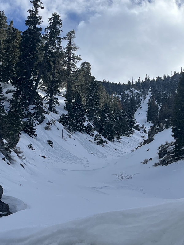
Active small Wet Loose activity noted around 4 pm
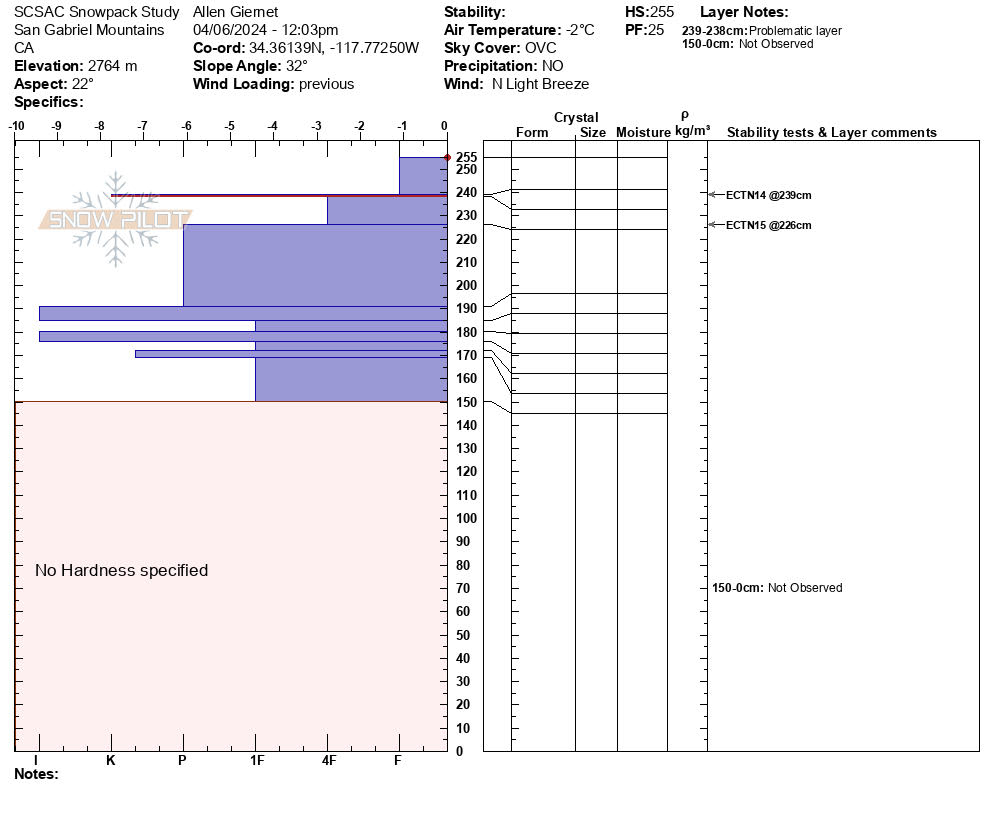
Pit profile North
|
Sponsors
|
|
|
|

|

|

|

|

|

|

|
|

|
|
|
|

|

|
Supporters
|
|
|
|

|
|
© 2013 - 2015 So Cal Snow Avalanche Center inc. All rights reserved.
P.O.Box 214 Tujunga, Ca. 91043 |
A 501(c)3 non profit organization # 46-2296801
|
Use at your own risk. This information is provided “as is” and in no event shall the providers be liable for any damages, including, without limitation, damages resulting from discomfort, injury or death, claims by third parties or for other similar costs, or any special, incidental, or consequential damages, arising out of the use of the information.