|
Observation type
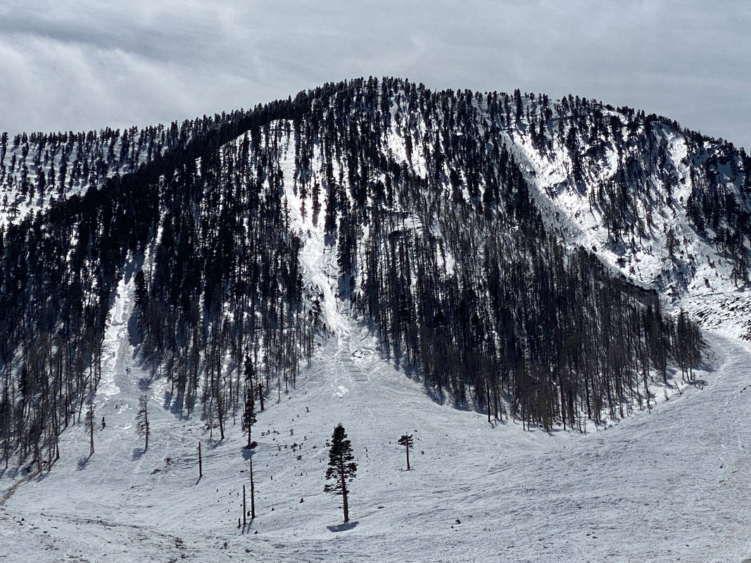
Avalanche Observer Kent Johnson Keep me anonymous if published no Location (general area) San Gorgonio area, Mt. Charlton, east couloir Latitude 34.11667 Longitude -116.84260 Date (yyyymmdd) 3/13/2023 Time 11:00 Road conditions to area Clear Temperature 47 f Sky clear (no clouds) Wind speed Moderate (17-25mph Small trees sway/ flags stretched) Wind direction not observed Wind direction in degrees NW Slope aspect East Aspect in degrees 90 Slope angle 30-40 Elevation 8500 Snow depth 6 feet + Boot/ Ski penetration Boot to knee, no slight penetration with Skis Precipitation None Activity, recent avalanches No Brief description Whumphing noises, shooting cracks. collapsing no Rapid warming yes Obvious avalanche path yes Terrain trap yes Comment Please see attached PDF writeup for the figures. It appears there were several simultaneous natural slides off of the east facing couloirs of Mt Charlton in the San Gorgonio area, See Figure 1. On the day of the observation, the temperature was warm (47 F at 9000 ft) and the overnight temperatures were above the freeze thaw cycle where the estimated freezing level was 10,500 ft (which is close to the estimated fracture point of 10,400 ft). There were light winds and clear skies in the morning with cloud cover in the afternoon. The snow fall for the areas (All of Southern California and Northern California) is being recorded as historic where over 200 inches was recorded for the season at the Big Bear local ski resort (just North of San Gorgonio area) at the time of the observation. Of those 200 inches, over 127 inches of snow fell between 2/21 to 3/3 (spanning 11 days), see Figure 2. The temperatures were unusually cold for the SoCal area where snow levels were below 4,000 ft (reaching as low as 1500 ft). The water loading was about 4 inches for the 127 inches of snow, see Figure 2. Then on 3/11 – 3/12 another 1 inch of water fell in the area (see Figure 2) with a freezing level of 11,000 ft which may have caused the light snow to form a slush or wet slab avalanche, see Figure 3. My estimates show that the fracture occurred and propagated the entire span of the east facing couloirs of Mt Carleton, see Figure 4. This avalanche had a path of about 1.42 miles with a width of 500 ft or more, see Figure 5 through Figure 8. It is estimated, based on previous hikes in the area, that the snow depth in the avalanche path is over 100 ft. Several very large trees were taken out from the avalanche and are included in the debris field, see Figure 9. This appears to be a natural slide that was triggered from weather and no one was caught in this slide. Due to the size, path length, and the descriptive nature of the avalanche, I would estimate this as a very large avalanche in the R4D4 rating which easily would have buried and killed someone if they were in its path. The conditions in the other areas in the San Gorgonio wilderness had a very icy surface that didn’t break during skinning at the 10,000 ft elevation, see Figure 10 Publish this observation Yes I would like this observation Published |
Click PDF below for full detailed report
| ||||||
Sponsors
Supporters
|
© 2013 - 2015 So Cal Snow Avalanche Center inc. All rights reserved.
P.O.Box 214 Tujunga, Ca. 91043 |
A 501(c)3 non profit organization # 46-2296801
|
Use at your own risk. This information is provided “as is” and in no event shall the providers be liable for any damages, including, without limitation, damages resulting from discomfort, injury or death, claims by third parties or for other similar costs, or any special, incidental, or consequential damages, arising out of the use of the information.


