|
Observation type
Snowpack Observer Anonymous Keep me anonymous if published yes Location (general area) San Bernardino Mountains Latitude Longitude Date (yyyymmdd) 20170104 Time 1409 Road conditions to area Clear with patchy ice Temperature 0° c / 32°F Sky Overcast (sky covered) Wind speed Moderate (17-25mph Small trees sway/ flags stretched) Wind direction NW Wind direction in degrees N/O Slope aspect South East Aspect in degrees 25° Slope angle 38° Elevation 9,846' Snow depth 39cm Boot/ Ski penetration 28cm/ 20cm Precipitation None Activity, recent avalanches No Brief description Whumphing noises, shooting cracks. collapsing no Rapid warming yes Obvious avalanche path yes Terrain trap yes Comment Skin from car with 10 - 20m at start 7:30am Several quick pits along the way showed varying depths of consolidating recent snow on a 1 to 2" ice crust at the base at 8,300'/ we found 6" of recent snow (consolidating powder on a rain crust of 1.5". This was on the older snow from Christmas eve to the thin ice layer at the ground. All bonding at consolidation well where we investigated. The snow pack appeared to be isothermic. Later investigation at 9,846 confirmed our suspicions of an isothermal snow pack. Also the rain crust had disappeared at this elevation. Only consolidating powder on the ice crust near the ground. Snow was soft the entire day. Warm temperatures and club cover in the afternoon was causing the lower elevation snow to become wet. This will lead to refreezing as will the rain that was moving in that night. Our stability test was CTN no reaction Snow pack varied in depth above 7,500' on Northerly aspects from 16" to 3'. still had to watch for shallow rocks and tree stumps. Probably the last day of good soft snow below 9,000'. Publish this observation Yes I would like this observation Published |

Skin track in lovely soft snow
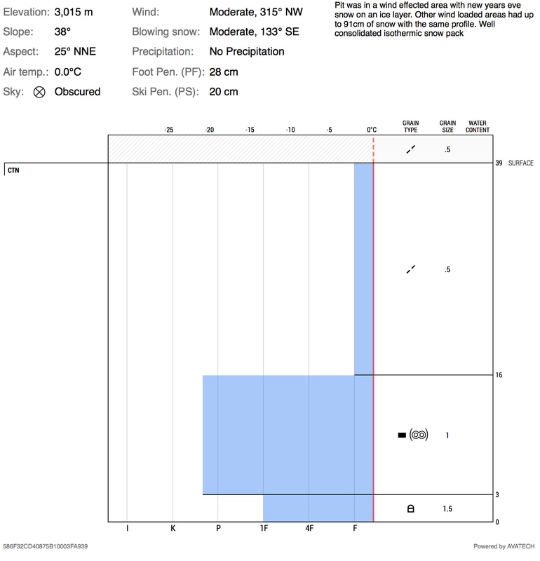
pit profile
|
Sponsors
|
|
|
|

|

|

|

|

|

|

|
|

|
|
|
|

|

|
Supporters
|
|
|
|

|
|
© 2013 - 2015 So Cal Snow Avalanche Center inc. All rights reserved.
P.O.Box 214 Tujunga, Ca. 91043 |
A 501(c)3 non profit organization # 46-2296801
|
Use at your own risk. This information is provided “as is” and in no event shall the providers be liable for any damages, including, without limitation, damages resulting from discomfort, injury or death, claims by third parties or for other similar costs, or any special, incidental, or consequential damages, arising out of the use of the information.