|
Observation type
Snowpack Observer Allen Giernet Keep me anonymous if published no Location (general area) Mt. Baden Powell Summit ridge North Bowl Latitude Longitude Date (yyyymmdd) 20161227 Time 1454 Road conditions to area clear with some small icy patches on N4. Note the posted Cal Trans closure at Vincent Gulch is actually at Grassy Hollow adding another 2 miles hiking the road to the trailhead. The road is clear but may have icy patches Temperature 4°C/ 39°F Sky 4°C/ 39°F Wind speed Calm (smoke rises vertically) Wind direction not observed Wind direction in degrees no wind Slope aspect North West Aspect in degrees 320 Slope angle 35° Elevation 9,000/2,743m Snow depth 24"/ 61cm Boot/ Ski penetration SP 3"/ 7.5cm Precipitation None Activity, recent avalanches No Brief description moderately heavy/wet snow with areas of dry snow Whumphing noises, shooting cracks. collapsing no Rapid warming yes Obvious avalanche path yes Terrain trap yes Comment We had to hike the road for roughly 2 miles from grassy hollow. On the north slopes adjacent to the rode we saw fairly vigorous pinwheel activity. Signs of the rapid warming and solar radiation at 8:00am around 7,000'/ 2,124m. 9:00am at the parking area 6,600'/ 2,012m there was 16"/ 41cm to 20"/ 51cm of consolidated storm snow on the ground. Ski Pen was 4"/ 10cm with easy skinning from this point. Had they not plowed the road to here we probably could have rode it all the way to the parking area. The road beyond the parking area had at least 24"/ 61cm of snow. From roughly 7,000'/ 2,124m to 8,880'/ 2,682m there was consistently 16"/ 41cm to 24"/ 61cm of storm snow on the ground with no base some areas were drifted in over 30"/ 76cm. Southern aspects were much less. NE and E aspects there was infrequent signs of roller balls and pinwheels even in sheltered tree areas due to the warming. We saw pinwheels up to 14"/ 36cm in diameter. There were patches of wind slabs and wind board but scattered sporadically with most snow a soft well preserved consolidated powder. Ski cuts and testing produced no results especially since this was all storm snow on ground with no distinct layers and consolidating very nicely. East/ Northeast and Southeast aspects were thin in exposed areas and sun effected/ melting out. The Northeast aspects in the trees were holding snow well but showing signs of the rapid warming. Near the summit ridge around 9,100'/ 2,774m there was more pronounced hard slabs and wind board but still very sporadic only in highly wind effected locations. Most of the snow maintained a consolidated soft powder nature. Above 8,800'/ 2,682m we started to find some base layering. At our pit location there was roughly a 10"/ 25cm base of various layers. See the attached pit profile. The upper 14"/ 35cm was storm snow and wind drifted storm snow. There was good consolidation through the pack as we tested it. The base was rain effected ice of about 2.5"/ 7cm with mixed rounds and rounding facets. We got a CT4Q3@21cm but were not able to reproduce this and a CT16Q3@16cm. We road North to Northwest aspects all the way to about 100'/ 30m of the road. It would have been rideable/ Skiable all the way except for the small rock field we encountered. It is still low tide but the snow has consolidated since the storm and become more supportable. Watch for buried logs, branches and rocks. Ride or ski alert and lightly and there are fantastic turns to be had. |
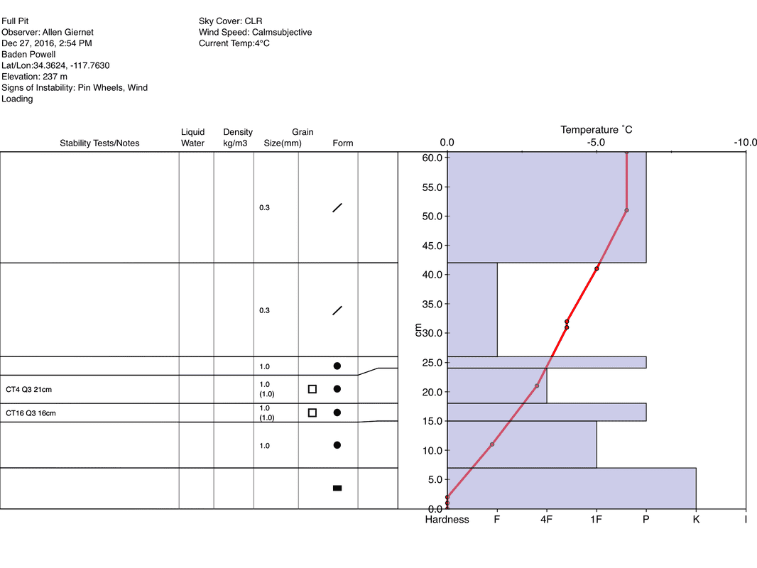
Pit profile note the 15cm layer and 18cm layer are rounding facets. The program I used did not have a symbol
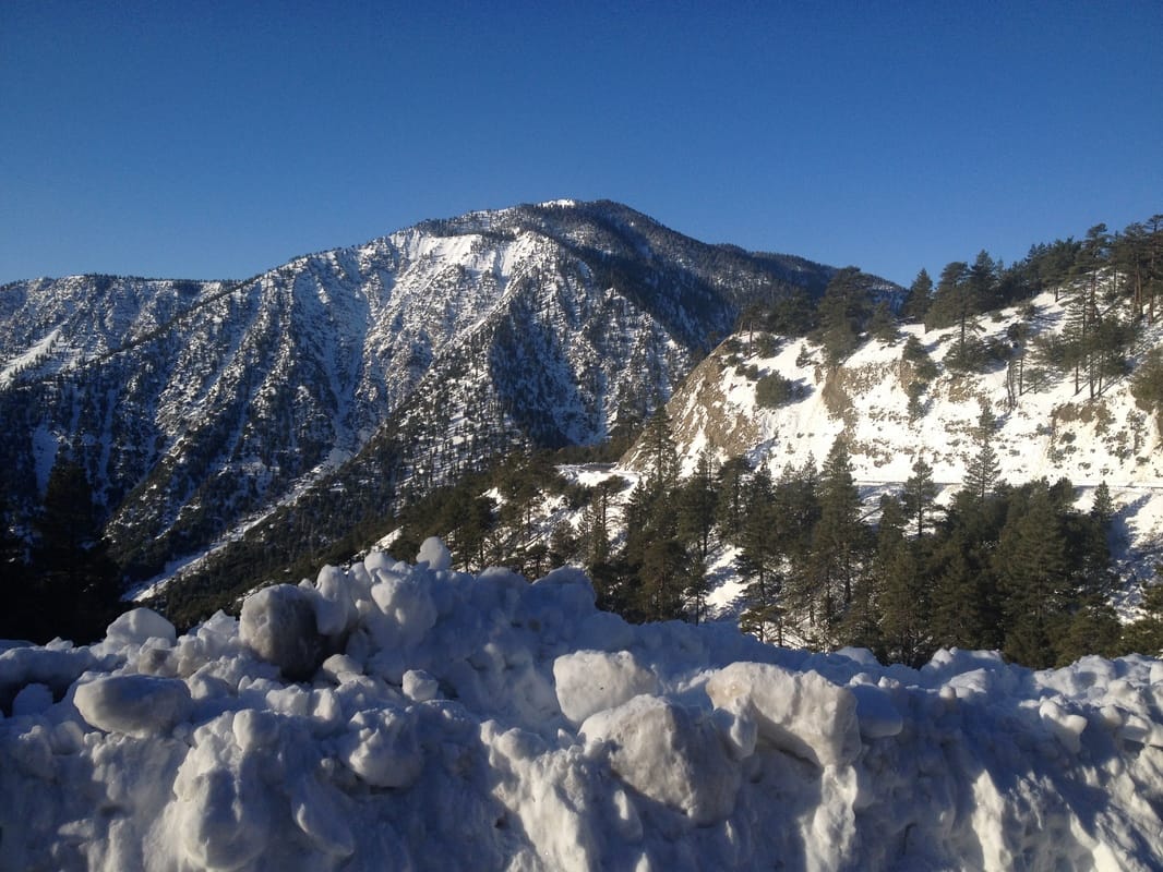
Looking towards Baden Powell from the 2 on the hike in
|
Sponsors
|
|
|
|

|

|

|

|

|

|

|
|

|
|
|
|

|

|
Supporters
|
|
|
|

|
|
© 2013 - 2015 So Cal Snow Avalanche Center inc. All rights reserved.
P.O.Box 214 Tujunga, Ca. 91043 |
A 501(c)3 non profit organization # 46-2296801
|
Use at your own risk. This information is provided “as is” and in no event shall the providers be liable for any damages, including, without limitation, damages resulting from discomfort, injury or death, claims by third parties or for other similar costs, or any special, incidental, or consequential damages, arising out of the use of the information.