|
Observation type - Snowpack
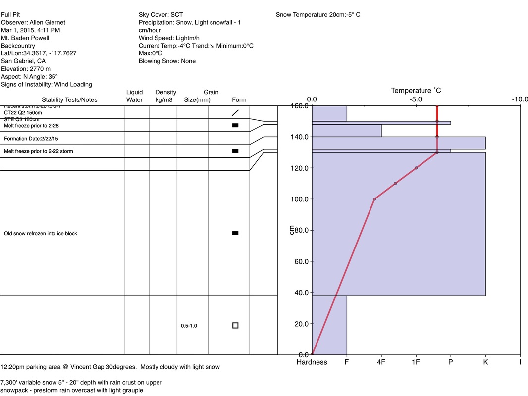
Observer - Allen Giernet Keep me anonymous if published - no Location (general area) - Mt. Baden Powell Latitude Longitude Date (yyyymmdd) - 20150301 Time - 4:11pm Road conditions to area - Clear Temperature - 30c Sky - Scattered clouds (3/8 to 4/8) Wind speed - Light (1-16mph Flags/twigs in motion) Wind direction - not observed Wind direction in degrees Slope aspect - North Aspect in degrees Slope angle - 35 Elevation - 2,770m Snow depth - 160cm Boot/ Ski penetration Precipitation - Light Activity, recent avalanches - No Brief description Whumphing noises, shooting cracks. collapsing - no Rapid warming - no Obvious avalanche path - no Terrain trap - no Comment 12:20pm parking area at Vincent gap temp 30 F. Mostly cloudy with light snow. 7,300' variable snow depth 5" - 15" with rain crust in upper snowpack from prestorm rain. Overcast and grauple at this time. 7,600' new snow 5" - 15" no crust and consolidated snowpack on N NE aspect. Overcast with light snowfall at this time. 8,000' no precip at this time homogenous snowpack no crusts 6" - 15" mostly recent snow from last two storms. 8,300' discovered older snow at base from before last two storms. Solid melt freeze layer to ground from extended warm period prior to the 2-22 storm. Base frozen 3" - 4" with 6" - 15" new snow on top. See pit profile for upper elevation. Here we found a solid thick ice layer on top of large facets. The ice layer was a very large melt freeze layer from the extended warm period prior to the recent storms. We did have some reaction on a melt freeze crust just below the 2-22 snow but nothing alarming. And the snow on top was loose new snow. |
|
Sponsors
|
|
|
|

|

|

|

|

|

|

|
|

|
|
|
|

|

|
Supporters
|
|
|
|

|
|
© 2013 - 2015 So Cal Snow Avalanche Center inc. All rights reserved.
P.O.Box 214 Tujunga, Ca. 91043 |
A 501(c)3 non profit organization # 46-2296801
|
Use at your own risk. This information is provided “as is” and in no event shall the providers be liable for any damages, including, without limitation, damages resulting from discomfort, injury or death, claims by third parties or for other similar costs, or any special, incidental, or consequential damages, arising out of the use of the information.